30 Jun

Tidepooling: Umbrella Crab

Two weeks ago I went to check out the lowest tide of the month. It happened to be at 8:06 am, so I took the morning off to go to the beach!

The low lying rocks were absolutely covered with long ribbons of kelp, which made it kind of treacherous to walk through. It also had a stronger rotting stench than I remember from other beaches. But once I got down there, and starting moving the kelp aside, I found some cool things underneath.

For instance, this pink crab! Pink!


I’ve never seen a crab like this little guy before. He’s well disguised to look like a rock covered with coralline algae, except that rocks don’t move around. He skittered a bit, so I saw him and got him and got a couple pictures before he walked himself off the rock where I set him and into a deep crevice, where I couldn’t even see him.


It’s a little bit blurry, but look at his funny little face! He’s so cute. It’s like if Tove Jansson designed a crab, this is what it would look like. I don’t think you can tell, but he has a little nose like Little My. If you’re not familiar with Little My, she’s the one with her hair in a bun.


I’d never seen a crab like that before, in color or in shape. I asked around and got the email for someone at the Alaska Department of Fish & Game who is into the intertidal critters. I sent him the pictures and he wrote back to say that it is a Cryptolithodes sitchensis, commonly called an umbrella crab. Wikipedia mentions that it is also called a Sitka crab, so how fitting that I should find my first one on a beach in Sitka. Check out the wikipedia page, they come in a wide range of colors. Very cool critters!

27 Jun

Flightseeing: Baranof & West Chichagof

Here’s some of the pictures from the flightseeing trip I got to sit in on earlier this month. In the last couple weeks things have suddenly been real busy, and I have a couple more sets of pictures in the pipeline.

This flightseeing trip was with some folks from the Alaska regional office of The Wilderness Society, who were showing their Senior Vice President of Conservation around the state, to see how awesome it is. TWS contributed funding for my position, so I got to go along for a bit.

We took off in a floatplane (a De Havilland Beaver, I believe) and headed west from Sitka towards Mount Edgecombe, which is picturesque, except that it was shrouded in clouds. Although we couldn’t see much of the high elevation sights, there was plenty to look at on the lower levels. For instance, here’s what happens on the land that is disturbed by logging roads and such.


All the rounded green texture is red alder, which moves in along the logging roads. It grows fast, and isn’t as commercially valuable as the spruce, hemlock or cedar. Below you can see the line of a road along the left side, then yellow green is new conifers growing back. On the right side you can see some uncut forest. It is speckled with gray – that’s yellow cedars which died up to eighty years ago, but which stay standing. When I first flew into Sitka, I assumed the dead trees were victims of the spruce bark beetle, which wreaked havoc in my home region, the Kenai Peninsula, but that’s the not the case at all. As the post glacial landscape here continues to evolve, or because of climate change, or because of the natural lifespan of a yellow cedar, they die. The wood is exceptionally resistant to decay and bugs (think cedar shavings, cedar chests, cedar homes), so it takes decades for the trunks to fall over.


In addition to flying over old and young growth forests, we flew over a lot of muskeg and a lot of coastline. From above, this beach looks about like places I saw on the Big Island in Hawaii last month, unless you can see its a conifer forest, not a jungle. Colder water, too!


Although the Tongass National Forest is well known for its trees, half of it is not forested at all. There are mountains and muskegs and rivers and lakes, but now that I’m here I see that a dominant characteristic is shoreline. Geographically, this area is the Alexander Archipelago, made up of thousands of islands.


The above group of islands is appropriately called the Myriads. I’m told the ones on the outside edge host a sea lion colony, which makes a ton of noise if you’re camping nearby.

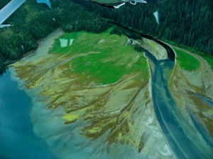
Below is another important piece of the coastal ecosystem – an estuary. Where a freshwater river runs out into the sea, spreading out sediments, making new land for lots of green things to grow on. In the spring and early summer (i.e. now) the bears come down to these areas to eat grasses in the estuaries. Later in the year the bears will be back to these areas, of course, when the salmon arrive and start heading upstream.

When we were in Hawaii, driving through the lush tropical jungle, there was a place where the guidebook claimed we would see shades of green we’d never seen before. Seeing these estuaries, I don’t think Hawaii has a monopoly on vivid greens.


We flew up the coast of West Chichagof and Yakobi Islands, a big chunk of which is a Wilderness Area, and counted about five boats. Then we cut across West Chichagof to Chichagof proper and stopped at a spot called Sitkoh Lake, which will be a restoration area soon. There are two Forest Service cabins on the lake, and we stopped by one of them and took a little walk in the marshy area at the head of the lake.


There were a lot of deer tracks in the mud, including some from a fawn that were absolutely tiny – about an inch long! We mucked about in the fen, and I decided that definitely needed to get on it and buy a pair of extra tuffs, the ubiquitious brown rubber boots that are called Sitka slippers if you’re in Sitka, or Ketchikan slippers if you’re in Ketchikan and probably Juneau slippers, Petersburg slippers, Kodiak slippers, too.

I saw a bit of movement down in the vegetation and found a toad, which everyone else took pictures of. He was two or three inches long, and had some yellow spots on his feet, but I couldn’t take a picture, because I was holding him, so here’s a wildflower that likes wet areas, called a shooting star, instead. Imagine the toad sitting underneath it, telling stories to his grandkids about the time he was captured by giant monsters with dry skin and flashing lights.


Back in the plane, they all insisted that I should sit in the front, so I got a good view. We flew across the mountains of Baranof Island back to the side that Sitka is on, but it was a lot of clouds that don’t make for good pictures. Here’s another verdant estuary, though.


Here’s Sitka from the air. The main town is on the left; the airport is on the island on the right.


I’m pretty sure that they artificially extended the island to make the runway.

So that’s the flightseeing. If you ever find yourself up here and want to go flightseeing, then the folks at Harris Air are the ones you want to talk to.

16 Jun

Sitka from the air

Link
Today there were a few folks in town from The Wilderness Society, which happens to be responsible for the funding for my collaborative position with the Sitka Conservation Society and the Forest Service. They included TWS Senior Vice President for Conservation, Amy Vedder, and I got to accompany them, along with the SCS executive director, Andrew Thoms, to fly up along the outer coast of Baranof, West Chichagof and Yakobi Islands. West Chichagof & Yakobi make up a great big Wilderness area, and getting it designated as such was the project that got SCS together as an organization in the 1960s.

It was really neat to fly over, and I’ll share more photos of it later (such as I was able to shoot through an airplane window with a little camera), but here’s Sitka from the air. If you see the red roof building in the middle, on the shore, and then a little below it a cluster of three brown roofed buildings, the smallest of the brown buildings is the Forest Service bunkhouse. As I said before, directly across the street from the beach! Tomorrow morning is the lowest tide of the month, and I’m taking the morning off to go poke some critters. Gently, of course!

12 Jun

My living quarters in Sitka

If you’ve been wondering what the Forest Service bunkhouse looks like, here ya go. One story, four bedrooms, two bathrooms. It’s on the edge of a gravel parking lot, which is surrounded by three buildings – a FS warehouse, another FS building which I suppose is a shop for working on boats/ATVs/cars/whatever, and ye olde bunkhouse. I say ye olde bunkhouse, because yesterday someone was visiting from another ranger district and said it looked the same when she first stayed there in the 1980s.

Also, the truck, as all FS road vehicles, are called “rigs.”

Above is my bedroom. It’s double occupancy, and I do have a roomie. Below is our kitchen.


Finally, here is our living room. As many buildings here do, we have a great big pasted together map of maps to show the area where we are. These vary in scale; the bunkhouse map shows Baranof Island and a bit of the surrounding islands. I think it would be 200-300 miles, north to south, in the territory it covers. We also have a television, and two vcr/dvd players because one of them is crummy on dvds, or maybe it was just the dvd from the public library was crummy. What you can’t see is the 15 vhs tapes that are part of the bunkhouse collection, including the entire set of the X Files. If I were into the X Files, that would be pretty exciting.


Also, here’s my bike. I’m glad I waited and refused to take any of the rusting mountain bikes that were offered to me, because not only were most of them too big, they were not nearly as nice as this bike.


Although I have been to the bikeshop with it three times in the first week – first to get it checked over and air in the tires, second to fix a flat because I went through the spare tube I bought, and third because a piece of the derailleur fell off, and I didn’t really want a single speed bike even though it is super flat here.

06 Jun

Getting settled in Sitka

Today I’ve been in Sitka for two weeks, and I have a stack of certification cards: Survival Egress Aviation Safety 4 Hour Dunker Course, Heartsaver (r) Bloodborne Pathogens, Coastal Kayak Basic Strokes & Rescues, 4-Hour Defensive Driving Course, First Aid/CPR/AED and a visitor status library card with the Kettleson Memorial Library. I didn’t get cards for aviation user safety, bear behavior & bear spray, Forest Service radio operation, hazmat first responder, or boat orientation, but I think I am getting a government driver’s liscense with an endorsement for ATVs, because I got trained for that, too.

So, you can tell that I am now very well prepared to fulfill my work plan, which directs me to write a factsheet on Tongass salmon, briefing sheets on watershed restoration projects on the Tongass National Forest, profiles of Forest Service staff involved in fisheries and watersheds, profiles of community members who rely on salmon, some glossy publications about all the fisheries and watersheds programs…

Actually, I am not being entirely facetious, since to get the info for the materials I’ll be producing, I will be spending some time “in the field,” as they say, and so will be traveling by boat, small plane, and quite possibly ATV or even kayak to get out there.

Out thar, because they are places that are only tenuously connected to what might be referred to as “civilization.” And I’ll let you know some lat and long when I go places and know them, but I know the plan is to go to Prince of Wales Island in about two weeks. POW is in the top five largest islands in the US, and is also one of the most heavily logged places in the Tongass NF.

In the reading I’ve done so far, I’ve started identifying stories, and one of the ones I think has the most potential is on POW. With the heavy logging there, and past practices really tearing up the landscape, there is a bit of flowing water there that got the name Fubar Creek. (If you’re not familiar with the term, let me direct you to the Urban Dictionary.) But Fubar Creek is a tributary into a larger bit of flowing water called the Harris River, and there has been a big watershed restoration effort going on there. I know it’s big, because the documents I’ve seen mention things like “Harris River Phase IV.” It seems like a really good place to use as a microcosm demonstrating the trajectory of the Tongass as a whole, and the name is priceless.

I should mention that one of the FS folks told me Fubar Creek will be officially renamed this summer, which is all the better, because nothing should be Fubar forever, especially in a National Forest. But if you were flipping through a paper, or, — let’s be realistic — scrolling through headlines online, wouldn’t Fubar Creek catch your eye? Wouldn’t you start reading that story?